Good Morning Race Fans!
Today kicks off the 2015 Race Season as Kaiser Racing puts two teams into events this weekend.
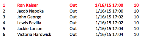
The festivities begin this afternoon as Uppa Ron (In our native language, Uppa is Grandpa) takes the trail with 10 dogs in the Bogus Creek 150. He will leave at 5:00pm and head up the trail to the Bogus Campsite Checkpoint. Mushers layover and camp out and then head back to Bethel. Unlike the K300, the Bogus Creek 15o allows a “Pit Crew” that will run up to the checkpoint and get the campsite ready and waiting. Ron hasn’t been on the race scene for several years, but has been on the runners as long as anyone. He’s excited to make the trip and should have a great time with 10 members of the Team!
Bogus Creek 150 Start Times
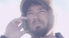
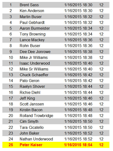
Pete and the Team are also anxious to get started. They have been training hard this year and Pete has said several times that this Team is really a barn burner. Strong and Young and Talented, this group has the makings of a great one, but the trail always puts challenges towards the best teams, so Pete will see how it goes. They are starting on the last duo from the Start Line and should get a good view of the Fireworks this evening.
The temperatures have been so warm that Officials are a bit worried about the Kuskokwim River. They are restricting vehicles from driving to the Start Line to keep as much weight off the area as possible. Usually the river is 30-40 inches thick at this point in the winter, but today it measures just over 23 inches. That is a good amount of ice, but if you combine a hundred vehicles, there is room for concern.
Weather is on the mend and temperatures will drop through the weekend. Considering it was raining last weekend, this is a welcome change.
K300 Racing Forecast-
KUSKOKWIM DELTA-
INCLUDING THE CITIES OF...BETHEL...HOOPER BAY...NUNIVAK ISLAND
331 PM AKST THU JAN 15 2015

...SEASONAL TEMPERATURES ON THE WAY BACK TO THE KUSKOKWIM DELTA...

A RETURN TO MORE SEASONAL TEMPERATURES IS EXPECTED THIS WEEKEND OVER
THE REGION AS COLD AIR FILTERS INTO THE AREA IN THE WAKE OF A WEATHER
SYSTEM THAT WILL BE PUSHING THROUGH WESTERN ALASKA ON FRIDAY AND
SATURDAY.

TEMPERATURES WILL BEGIN TO FALL OVER THE AREA SATURDAY AFTERNOON WITH
OVERNIGHT LOWS NEAR ZERO FOR SATURDAY AND SUNDAY NIGHT AND AFTERNOON
TEMPERATURES REACHING 10 TO 15 ABOVE ZERO FOR SUNDAY AND MONDAY.
ACCOMPANYING THESE TEMPERATURES WILL BE NORTHWEST WINDS OF 10 TO 20
MPH...WHICH WILL BRING WIND CHILL TEMPERATURES DOWN TO 10 TO 20 BELOW
ZERO.

RESIDENTS IN THE KUSKOKWIM DELTA ARE URGED TO BE PREPARED FOR MORE
SEASONAL WEATHER CONDITIONS RATHER THAN THE WARMER MORE FALL LIKE
CONDITIONS THAT HAVE BEEN COMMON THE LAST SEVERAL WEEKS. REMEMBER TO
LEAVE A TRAVEL PLAN WITH FRIENDS OR FAMILY IF YOUR WEEKEND PLANS
INCLUDE TRAVEL IN THE REGION.
.TODAY...LIGHT FREEZING RAIN LIKELY...CHANGING OVER TO SNOW IN THE
AFTERNOON. ICE ACCUMULATION LESS THAN ONE TENTH OF AN INCH. WEST
OF BETHEL...SNOW LIKELY. SNOW ACCUMULATION 1 TO 2 INCHES. HIGHS IN
THE 20S. NORTHEAST WIND 10 TO 20 MPH EXCEPT NORTH 15 TO 30 MPH
ALONG THE COAST.
.TONIGHT...SNOW SHOWERS...WITH A CHANCE OF FREEZING RAIN SHOWERS
IN THE EVENING EAST OF BETHEL. SNOW ACCUMULATION UP TO 2 INCHES.
LOWS 10 TO 15 ABOVE. NORTHWEST WIND 10 TO 25 MPH
.SATURDAY...NUMEROUS SNOW SHOWERS IN THE MORNING...THEN SCATTERED
SNOW SHOWERS IN THE AFTERNOON. SNOW ACCUMULATION UP TO 1 INCH.
HIGHS 10 TO 15 ABOVE. WEST WIND 10 TO 20 MPH.
.SATURDAY NIGHT...MOSTLY CLOUDY WITH ISOLATED SNOW SHOWERS.
PATCHY FOG. LOWS ZERO TO 10 ABOVESOUTH WIND 15 MPH.
.SUNDAY...PARTLY CLOUDY WITH ISOLATED SNOW SHOWERS. HIGHS 5 TO 20
ABOVE. SOUTHEAST WIND 10 TO 20 MPH.
.SUNDAY NIGHT...MOSTLY CLOUDY WITH A SLIGHT CHANCE OF SNOW. LOWS
10 TO 15.
.MARTIN LUTHER KING JR DAY...PARTLY CLOUDY. HIGHS 15 TO 20.
.MONDAY NIGHT AND TUESDAY...MOSTLY CLOUDY WITH A CHANCE OF SNOW.
LOWS AROUND 10. HIGHS AROUND 20.
LOWER KUSKOKWIM VALLEY-
INCLUDING...ANIAK...SLEETMUTE
440 AM AKST FRI JAN 16 2015

...FREEZING RAIN ADVISORY REMAINS IN EFFECT UNTIL NOON AKST
TODAY FROM SLEETMUTE WEST...

.TODAY...MOSTLY CLOUDY WITH SCATTERED FREEZING RAIN SHOWERS IN
THE MORNING...THEN A CHANCE FOR RAIN OR FREEZING RAIN IN THE
AFTERNOON. FROM SLEETMUTE WEST...LIGHT FREEZING RAIN LIKELY IN THE
MORNING...BECOMING RAIN IN THE AFTERNOON. ICE ACCUMULATION LESS
THAN ONE TENTH OF AN INCH. HIGHS IN THE 30S. EAST WIND 10 TO 15
MPH.
.TONIGHT...MOSTLY CLOUDY. SCATTERED RAIN SHOWERS IN THE EVENING...
THEN SCATTERED RAIN AND SNOW SHOWERS AFTER MIDNIGHT. LOWS IN THE
20S. SOUTHEAST WIND 10 TO 15 MPH.
.SATURDAY...SCATTERED SNOW SHOWERS IN THE MORNING...THEN NUMEROUS
SNOW SHOWERS IN THE AFTERNOON. SNOW ACCUMULATION UP TO 2 INCHES.
HIGHS IN THE MID 20S TO LOWER 30S. VARIABLE WIND 10 MPH.
.SATURDAY NIGHT...MOSTLY CLOUDY WITH SCATTERED SNOW SHOWERS. LOWS
5 BELOW TO 5 ABOVE. VARIABLE WIND 10 MPH.